Projects
IPEX
Background
The Intelligent Payload Module (IPM) concept for the proposed Hyperspectral Infra-red Imager (HyspIRI) mission would involve both ground and flight automation. On the ground, users would use Google Earth to specify geographical and seasonal areas of interest. These requests would be automatically combined with predicted overflights to develop a schedule for onboard product generation and downlink. Onboard the spacecraft, the collected instrument data would be analyzed to search for specific event or feature signatures, such as a forest fire, volcanic eruption, or algal bloom. These detected signatures could generate alerts or products that would be prioritized and merged to drive spacecraft operations.
IPEX is a CubeSat mission that validated and matured the HyspIRI IPM concept. IPEX did not have an actual science-quality instrument and had a much shorter mission lifetime. However, IPEX was designed to (and did) generate large amounts of data and process it onboard using a highly automated mission operations flow, just like the HyspIRI IPM.
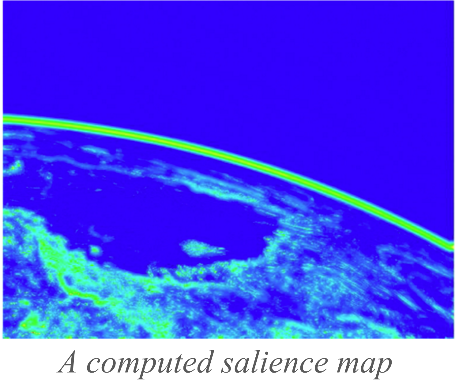
IPEX used machine-learned random decision forests to classify images onboard (to downlink classification maps) and computer vision visual salience software to extract interesting regions for downlink in acquired imagery. Also, IPEX flew the Continuous Activity Scheduler Planner Execution and Re-planner AI planner/scheduler onboard to enable IPEX operations to replan to best use spacecraft resources such as file storage, CPU, power, and downlink bandwidth
Problem
Future space missions will produce immense amounts of data. A single image from the HiRISE camera on the Mars Reconnaissance Orbiter spacecraft can be as large as 16.4 gigabits(uncompressed) The HyspIRI mission concept under study proposes to have two instruments 1) the HyspIRI thermal infrared imager, projected to produce 1.2 million pixels per second with eight spectral bands per pixel at 4 and 7.5–12 μm; and 2) the HyspIRI visible shortwave infrared (VSWIR), projected to produce 300 thousand pixels per second with 220 spectral bands per pixel in the 0.38–2.5 μm range. These data rates will require efficient algorithms, streamlined data flows, and careful systems engineering.
Specific ground users need access to derivative products of the data for a range of applied science usages of the HyspIRI data. These uses include detection and estimation of volcanic activity and forest fires, tracking of volcanic and forest fire plumes, tracking of flooding events, measurement of snow extent, and other applications.
Onboard production of science and applications products can enable local users to utilize the Direct Broadcast Technology to receive regional data effectively as the data is acquired by the spacecraft. Onboard product generation reduces the burden on local users and enables rapid exploitation of the satellite data.
Impact
IPEX validated onboard generation of over 31,000 image products generated with near-continuous autonomous operations with 100% reliability. IPEX also validated direct broadcast, autonomous science, and product delivery technologies supporting Technology Readiness Level (TRL) advancement relevant to future climate science measurements such as the Intelligent Payload Module (IPM) targeted for the proposed Hyperspectral Infrared Imager (HyspIRI) Earth Science Decadal Survey mission concept.
Status
IPEX launched in December 2013 for a six month mission, achieved its success criteria in three months, and flew for 14 months completing operations in 2015.
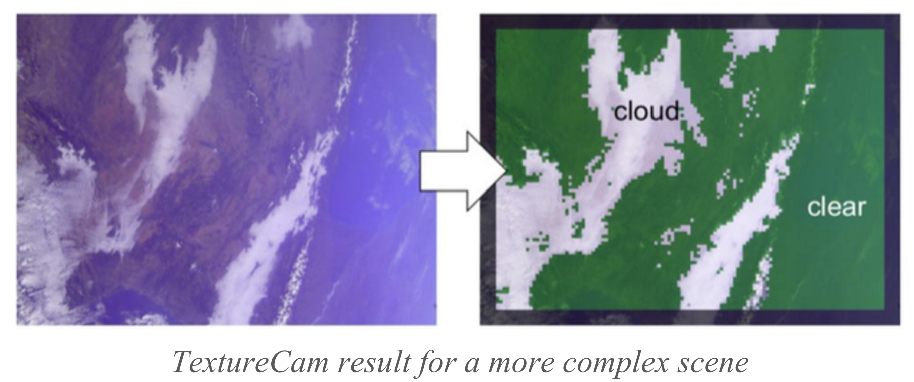
Further development and testing would be needed to extend the data analysis algorithms (TextureCam and salience assessment) to the spectral data cubes that would be collected by HyspIRI.
The number of candidate features for TextureCam would grow multiplicatively with the addition of more image bands, but this would only affect the classifier training process, which is conducted on the ground. The salience algorithm could be given a grayscale version of the data cube to assess, or it could be applied independently to the data collected at different wavelengths, with the results fused into a single salience assessment at the end. The latter approach requires more computational effort but could be deemed worth the cost if there is independent, complementary information contained in different bands.
Description
IPEX validates a wide range of onboard instrument data-processing algorithms. A large class of these algorithms is based on simple arithmetic operations on the observed pixel values (e.g., normalized difference ratios, band ratios, and similar products). For example, the detection of flooded pixels to enable the calculation of surface water extent is based on band ratios. Snow and ice detection can also be done using simple band-processing formulae. Thermal anomaly detection algorithms employed for volcanic eruptions and active fire mapping also involve computationally efficient slope analysis of spectral signals. Finally, a wide range of vegetation indicators also involve difference ratios or similar computations.
For information on CASPER, IPEX's onboard planner, see here
Publications
Team
Jet Propulsion Laboratory, California Institute of Technology:- Steve Chien
- Joshua Doubleday
- Elly Shao
- David Ray Thompson
- Alphan Altinok
- Kiri Wagstaff
California Polytechnic University, San Luis Obispo:
- John Bellardo
- Jordi Piug-Suari
- Craig Francis
- Eric Baumgarten
- Austin Williams
- Edward Yee
- Eric Stanton
Goddard Space Flight Center:
- Thomas Flatley
- Gary Crum
- Alessandro Geist
- Michael Lin