Projects
Thailand Flood Sensorweb
Background
The Thailand Flood Sensorweb is a collaboration of NASAs Jet Propulsion Laboratory and the Hydro and Agro Informatics Institute of Thailand. In this effort, sensorweb technologies are being used to enhance monitoring of flooding in Thailand. The Thailand Flood Sensorweb utilizes automation techniques to detect flooded areas, alert interested parties, retask remote sensing assets to acquire high resolution imagery, derive analysis products from this imagery, and deliver this imagery. This system has been in operations during the last three flooding seasons and has rapidly delivered more than 100 analysis products.
The Thailand Flood Sensorweb is funded by the NASA Earth Sciences Technology Office (ESTO) to develop and demonstrate how advanced modeling, command and control, data interpretation, and product delivery technologies can enhance monitoring of terrestrial phenomena such as flooding.
Problem
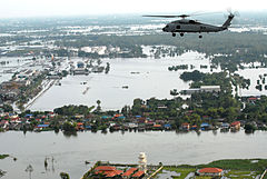
Flooding has a tremendous impact on humanity and is worldwide in scale.
Thailand (as well as greater Southeast Asia) is particularly prone to
flooding, as observed during the 2010-2011 and 2011-2012 flood seasons in
Thailand. The Thailand flood of October-November 2010 was responsible for more
than 200 deaths, caused more than 1.67 billion (U.S.D.) in damages, and
affected more than 7 million people. The 2011-2012 flood season was even more
severe, accounting for more than 600 deaths and 45.7 billion (U.S.D.) in
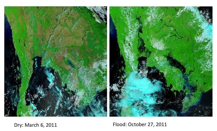
damage. Below MODIS imagery shows the extent of the flooding in the 2011-2012
flooding season (images credit LANCE-MODIS, NASA GSFC).
Description
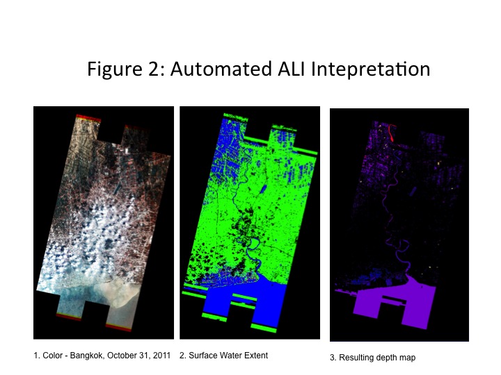
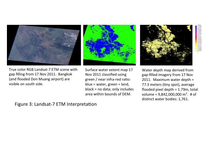
The sensorweb system can automatically detect flooded areas using MODIS imagery and can also accept manual notifications from Thai authorities. The automatic MODIS-based flood detection retrieves MODIS band 7-2-1 subset data and uses green and infrared bands to distinguish flooded areas from land. Flooded area pixel counts are then compared to dry season baseline measurements to detect flooding.
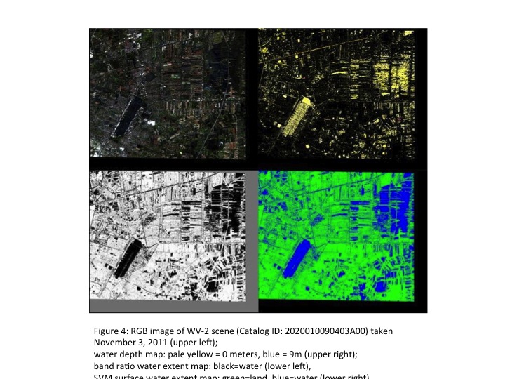
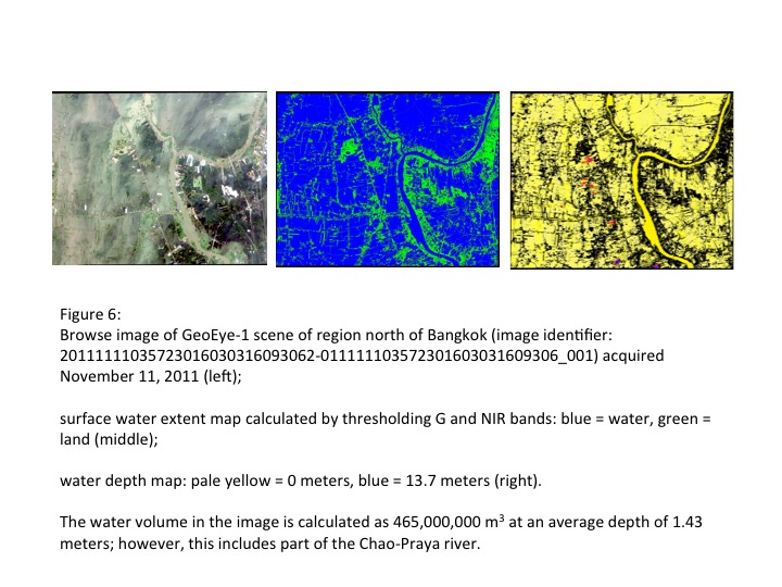
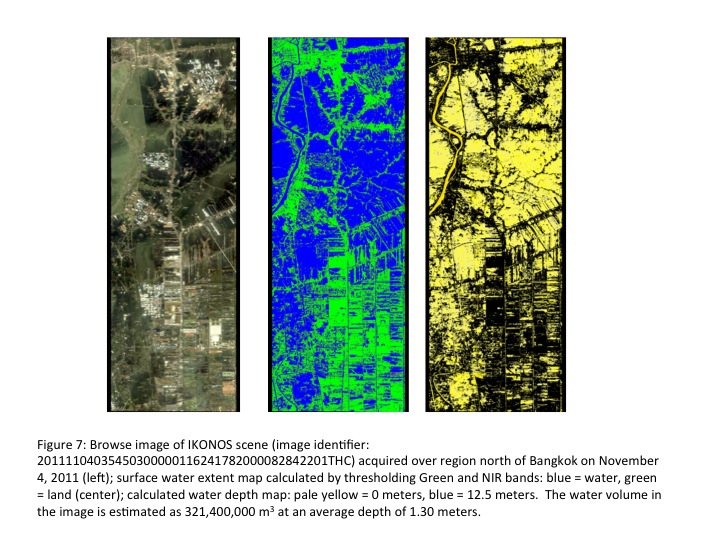
These detections/alerts then trigger an automated response system using the Earth Observing-1 (EO-1) spacecraft but also including semi‐manual and manual alerts to a range of space assets. The EO-1 spacecraft has an automated tasking system that accepts urgent, “last minute” electronic observation requests and will fit them into the operational schedule based on pre-determined mission priorities. In partnership with other missions, we also generate electronic requests and notifications of these flooded area targets that are then forwarded to appropriate disaster response points of contact. Once the data is acquired, a combination of automated and semi-automated processes are used to access the data. Once the data is retrieved, workflows automatically determine surface water extent using both support vector machine-learned classifiers and ratios of green to infrared spectral bands. Surface water extent maps are then combined with digital elevation map information to produce water depth maps. Both of these products are then automatically electronically pushed to HAII.
Depending on timing and the sensor, this entire process from detection to
product delivery can take anywhere from one to several days. In the past,
three flood seasons products have been developed and delivered using the Thai
Flooding Sensorweb from a range of space-based satellites and sensors
including: EO-1 (ALI, Hyperion), Worldview-2, Ikonos, GeoEye‐1, Landsat 7, and
Radarsat‐2. Samples of the input imagery and products for EO‐1/ALI (Figure 2.
Image credit NASA GSFC), Landsat 7 (Figure 3. image credit USGS), and
Worldview-2 (Figure 4, image credit Digital Globe), Geo-Eye 1 (Figure 6, Image
Credit Geo Eye), Ikonos (Figure 7, image credit Satellite Imaging Corp. ).
Publications
Team
JPL: Steve ChienJoshua Doubleday
David Mclaren
Daniel Tran